Thursday, April 6, 2017

Murano and Burano


On suggestion from a friend, we decided to visit these islands on our own instead of choosing a half day tour. I located the boarding point for the Vaperatto while on my morning run along the Grand Canal. Yes...I went out for a run again but today was much colder (around 8 degrees in Celsius) so I decided to wear pants and a fleece. But today being Monday, the crowds were much higher so I skipped the narrow lanes and stuck to the wider  streets along the Grand Canal

Around 10 am, we reached the Vaperatto station at Piazzale Roma but we just missed the boat/ferry to Murano. The next one was after 20 minutes and it was a slow one with various stops along the way (Line 4.2). However, we later discovered that the one that takes 17 minutes is extremely crowded (Line 3).

Anyways, we boarded the Line 4.2 for Murano and it took us about 45 minutes to reach Murano Museo - the last stop in Murano. For tourists it is the best stop as there is a wonderful glass museum just couple of hundred meters away.

Since we hadn't had breakfast, we first got some coffee and then paid 10 euros to gain entry into the glass museum. The museum turned out to be a very pleasant surprise. We first watched the silent video that showed various kind of techniques used to produce the amazing glass products. After that we spent over an hour admiring the collections. Below are some of the pictures I clicked in the museum.

A glass centerpiece designed like an Italian garden with fountains, arches, pots with flowers, flowerbeds.


After the museum visit, we chose to have lunch before taking the Vaperatto for Burano as that was another 35 minutes ride. The colder morning had given way to a warm and sunny afternoon. We sat by the water, sipped on some spritzer (apparently that's almost a religion in Venice!)  and had some lasagna. Such afternoons are the best part of visiting Europe...small cafes...sitting out in the open, enjoying the breeze & sun (and in this case water as well) and watching the world go by.  
 
Post this long leisurely lunch we took the Line 4.2 to Murano Faro as that's the stop for boarding the Line 12 for Burano. The crowd waiting for Burano was huge and we wondered if we would even get to board the ferry. Our fears were unfounded as this was a much larger boat and could fit all of us in - but we had to stand for the entire journey of 35 minutes.
View of Murano as we left for Burano

A canal in Burano

A quirky window display in Burano
 
Burano turned out to be another beautiful and sleepy island...so sleepy that the lace museum was closed :). So we simply walked around, enjoyed a gelato, had some Prosecco & calamari and after about an hour or so, boarded the Line 12 back for Murano Faro.
 
Line 12 also goes to Venice but not to Piazzale Roma, so we decided to change to Line 3 at Faro. Line 3 turned out to be like a Mumbai local in peak time...but it did get us to Venice in less than 20 minutes.
 
We wanted to retire early today as we had spent more than 2.5 hours standing (waiting for ferries and then on the ferry). And I always feel more tired when standing vs while walking. But before that we wanted to pick up some venetian masks and a coffee maker that can be used on regular gas stove.
So we again walked down Strada Nova, picked up some beautiful masks but couldn't find the coffee maker. The mask vendor suggested the COOP store at Piazzale Roma for same and since it was on way back to apartment, we decided to check it out. And yes, we did find it at the COOP store :)
 
So, here is how it works...there are three parts to it - the top part can be unscrewed, middle part is to add the coffee powder, and you add the water in the bottom chamber till the steam vent. When you heat it on stove, the water comes through the coffee filter, rises up the central column and fills the top chamber. Pretty cool!
 
With the shopping done, we picked up some dinner and Bellini to enjoy the last evening in Venice in the comfort of the beautiful apartment with lovely views, as next morning we had an early start to catch 7:35 am Frecciarossa to Naples.


Monday, April 3, 2017

Venice

I had my heart set on Venice for a long time, even though there were many not-so-great reviews of the place. I, however, wanted to visit it before it vanishes due to the rising sea levels. Hence, despite all warnings, I planned a short (3 night) trip to Venice. And I wasn't disappointed!

We had a flight via Paris and we landed at Venice Marco Polo airport at 2:30 pm. I had arranged a taxi pick-up through my Airbnb host and we were in her beautiful apartment by 4 pm. The apartment overlooked a canal and was just 5 minutes walking distance from Piazzale Roma - the principal arrival point in Venice. The square acts as the main bus station for Venice and is close to the main Santa Lucia (Ferrovia) railway station.

We both had only one medium sized wheeled bag and one backpack each, so it wasn't difficult to traverse the three bridges to the apartment. One must keep that in mind when visiting Venice - the transport will not reach your doorstep and hence big luggage or more than one wheeled bag per head isn't easy to handle.

Since it was already 4 pm, we decided to just walk around the area and get a feel of the place. Only item on the agenda was to procure a local sim card because we couldn't find any outlet at the airport. Our driver had suggested that we might find outlets for TIM, Wind and Vodafone (3 key mobile operators) on Strada Nova (new street). So we went past Piazzale Roma, climbed over the Ponte della Costituzione (a modern footbridge over the western end of the Grand Canal) and started our hunt.


Masks on display
We were tired due to lack of sleep the previous night and 4 hour layover, but the street was fun and we were enjoying our walk. There were shops and vendors of all kinds. After about a mile of walking, we found a big TIM outlet but the queue wasn't moving (there were 3 women with a dog who weren't interested in leaving the counter), so we went ahead to Vodafone store & found them to be too expensive. On way back to TIM store, we ran into Wind store and discovered that they cant promise activation soon as their systems are down. With heavy heart, we went back to  TIM store and guess what - those 3 women were still there!!! Though thanks to them, rest of the waiting customers had left.

A gondola along the way

Finally we acquired a local sim, picked up some milk (for my morning coffee) from a COOP store near by and sat down just next door for an early dinner. We ordered Prosecco (Italian sparkling wine), Lasagna Bolognese and Mushroom Risotto. While wine and Risotto were good, Lasagna was just amazing. It turned out to be a really lovely meal. After the meal, we slowly walked back to the apartment while enjoying a gelato :) 


Sunset view from our bedroom window


The apartment was simply wonderful with lots of space - bedroom, living room, kitchen and decent sized bathroom. Our host had provided us all kinds of tea and coffee, fruits, breakfast snacks, some yoghurt and even a bottle of Prosecco. The bathroom had everything we needed including a hair dryer. The view of the canal from the bedroom was as promised - overall the place was actually better than as seen in the photos. We were quite tired by now and hence we retired by 8:30 pm

Next day I woke up at 7 am, and after coffee, went out for a run. Long ago, I had watched a Woody Allen movie in which Julia Roberts runs by the canals of Venice (Everyone Says I Love You). Ever since, I had wanted to run in Venice. Since the temperature was around 13 degrees in Celsius, it was perfect for a morning run. It was a Sunday and there were hardly any people in the streets. It was fun to run along the Grand Canal, the smaller canals, through bridges and narrow lanes...I was happy!!!


View of Grand Canal from Rialto Bridge
Late morning, we decided to walk to Piazza San Marco (St Mark Square). It took us about 45 minutes to get there through Ponte di Rialto (Rialto Bridge). It is the oldest bridge among the four bridges that span across the Grand canal, and was the dividing line for the districts of San Marco and San Polo. Earlier it was made of timber and the present stone bridge was completed in 1591 and is similar to the wooden bridge it succeeded.


Basilica Di San Marco as viewed from St Mark Square


By the time we reached the Basilica Di San Marco, it was 11:30 am and almost the time for Sunday mass. Since the Basilica would open again at 2 pm, we decided to grab some wine & snacks in a nearby restaurant.

There was live music, throngs of crowds, pigeons and seagulls...a very lively scene. The weather was sunny but not hot - a perfect noon to sit and relax!


Bridge of Sighs


After a while, we walked along the Grand Canal and saw Ponte dei Sospiri (Bridge of Sighs). The enclosed bridge is made of white limestone, has windows with stone bars, and passes over the Rio di Palazzo and connects the Prigioni Nuove (New Prison) to the interrogation rooms in the Doge's Palace. The name comes from the suggestion that prisoners would sigh at their final view of beautiful Venice through the window before being taken down to their cells


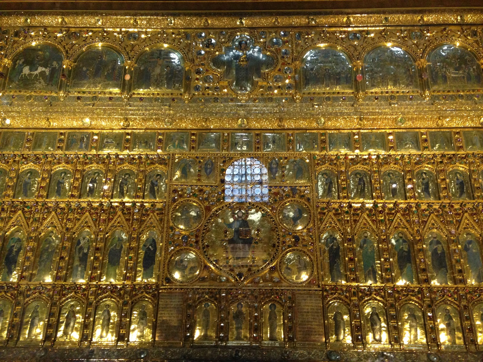
The Pala d’Oro–an incredible gem-encrusted gold altar piece


It was almost 2 pm, so we walked back to the Basilica, deposited our backpack nearby and finally entered the building. Photography is not allowed but I did manage to click a picture of the Pala d’Oro–an incredible gem-encrusted gold altar piece.

I decided against climbing the Campanile bell tower next to Basilica- because actually there is no climb - an elevator takes you all the way to the top - no fun!!!


After the visit to Basilica we continued our walk along the Riva degli Schiavoni (waterfront) for a while. We enquired about the Gondola ride (costs 80 euros for 30 minutes) but decided against it.

Instead we picked up a 20 euro 24 hour Vaperatto pass for visiting Murano & Burano next day. Soon after, the gathering clouds forced us to make our way back to our apartment - though we chose a bit longer but different path to get back. It did start to rain on the way back but our rain jackets helped. Thus ended a beautiful sunny day in the lovely city of Venice


Monday, March 20, 2017

Kuari Pass Trek

I usually don't hike in India due to paucity of good lodging along the trek route. However a friend had done Roopkund trek with India Hikes (IH) and had a great experience. Plus this was a short trek of 4 days with camping requirement of only 3 nights. So I signed up for this winter trek in Garwhal region of Uttarakhand.

3 of us (batch mates from B-school) met at Delhi airport, flew to Dehradun and took a cab to Haridwar. This was my first tryst with Ganges up close and that too in the Dev Bhoomi. We spent the evening walking along the holy river and enjoying the quiet of a smaller town. 

We met the rest of the group next day at 6:45 am. We were total 7 of us - this was a low number as against the usual 20 pax that IH has in one group. It was to be a long (10 hours) drive to Joshimath base camp so we decided to take two cabs instead of packing all of us and our backpacks in one Sumo. 

The route, although long, was very scenic and road quality was good. During this journey we witnessed four of the five river confluences listed from downstream to upstream order:
  • Devprayag, where the Bhagirathi joins the Alaknanda to form the Ganges.
  • Rudraprayag, where the Mandakini joins the Alaknanda;
  • Nandprayag, where the Nandakini joins the Alaknanda; 
  • Karnaprayag, where the Pindar joins the Alaknanda 

Devprayag
Vishnuprayag (the first one upstream), where the Dhauliganga joins the Alaknanda is the one we couldn't see up close. I am not a very religious person but I did find these confluences mystical and magical! 

While the roads were wide, their wavy nature did create queasiness and resulted in fatigue by the time we reached Joshimath at 5 pm. However, some of the tiredness vanished once we reached the base camp. The base camp accommodation was a hostel and it was really good and clean. I was quite impressed with the arrangements. Here we met with our Trek Leader and were briefed on safety, trek route and being Green throughout the trail (means don't trash and pick up anything thrown by others)

After a sumptuous dinner that included Jalebis for dessert, we retired for the night. Given I was the only female in this 7 member group, I had the room to myself and the 6 men were in a large dormitory. While I was a little bit jealous at all the fun they were having (could hear their laughter down the hall), I was happy to have the entire bed and two blankets to myself. 

Sometime during middle of the night I woke up to a strange sound and found that it was completely dark (power failure) and some strange white light was blinking on the ceiling. When I couldn't figure out the source of it, I found myself wondering if there was an astral presence around...but soon I realised that it was the blinking of an unread message on my phone...phew!!!

Next day we woke up in complete darkness (there was no power still) and started packing our backpacks. Cold shower was out of question in 8 degree Celsius temperatures, so we all got ready well in time for breakfast and morning health check - that included BP measurement and oxymeter reading. During the course of trek, oxymeter readings were taken atleast thrice a day - morning, on arrival at camp and evening before dinner. Plus BP measurements were taken if anyone had a persistent headache. 

After breakfast, we all boarded a vehicle for Auli - our start point for the trek, couple of people had decided to offload their backpacks to the porter and the porter was also supposed to meet us there with the mule(s).

It was bright sunny day with no clouds in sight - disappointing because there had been no snowfall yet and the winter trek had started to feel like a bad summer trek (usually summer treks have green grass and blooming flowers and here everything was brown or grey). Today was supposed to be an easy day and it really was. 


Despite all attempts by our trek leader to slow us down (like numerous breaks and a tea halt) we reached the campsite of Gursan Bugyal at 12 noon. This is at 3056 m (10,084 ft) and is located just 3 km from Auli. Bugyal means meadows but there wasn't much lush greenery around as it was winter. The bugyal must be impressive when green in spring/summer or when it has the white background of snow covered mountains. While it was still beautiful against the stark brown range of Garwhal mountains, we all kept wondering what it could have been had it snowed.
 
The campsite had around 10 tents, a dining tent and a kitchen tent. There were 3 toilet tents - as expected a little far from the main site. The water for cleaning etc. was in drums and obviously would freeze overnight. But overall the arrangements seemed good except for lack of any seating in dining tent. The floor was uneven and since no one wants to take off their boots, the tarp was always dirty. There honestly wasn't a truly comfortable position one could sit in.
 
Acclimatization Walk
Since the weather was sunny, we found ourselves some comfortable spots in sun to have our lunch. After lunch and some rest, we went for a acclimatization walk. It was a really short walk - almost laughable compared to the ones I have done on my earlier hikes. Anyways, we had fun and reached the camp in time for tea and popcorn. 
 
Gursan Bugyal (meadow)
The evening was getting cooler and most of us retired into tents - I was alone as I was the only female and others were two in each tent. I honestly liked being alone in the tent. Loved the privacy that allowed me to clean myself up and change into comfortable clothing for the night and was thankful for the extra space. Normally they put three in a tent, not sure I would ever be able to handle that.
 
Dinner was served around 7 pm. it was pretty sumptuous for a camping trek and we all ate more than we needed to. Sated we retired to our tents for the night. At night, we were told to inform the tent-mate while stepping out for nature's call. This was to ensure that if a wild animal or any confusion doesn't allow one to return to tent, the rescue can start in time. Since I was alone, I tried to wake up tenants of the other tent and only answer I got was "keep on moving"!!!! After that I never tried waking up anyone :)


Our trek leader was an instructor at NIM and hence we followed the same method of informing us about the wake up tea etc.  6-7-8 (implies 6 am tea, 7 am breakfast, 8 am departure). I woke up before time and waited for the tea -which sadly turned out be a sugar water with a hint of tea. I was quite upset because I expected regular milk tea and after much negotiation, I was provided with same. But I lost about 20 minutes in the process. I tried negotiating with trek leader to delay the start time but he was adamant that we have to leave at sharp 8. Anyways, having done the course at HMI, I was able to manage packing my bag and sleeping bag much faster and was ready on time.
 
Today's hike started with sights of a beautiful sunrise, the day that started fairly cold (the water in drums was frozen) gave way to a very sunny and warm late morning. We walked slowly, took some photos along the way and finally came to a formal resting point before starting on a bit treacherous route.
 
To be honest most of us didn't find this route tough but another group that traversed the same from the other side had a few folks that were a bit rattled. Some of them even made a small scene which we enjoyed while eating our Bengal gram snack (which later on proved to be our undoing).
 
After the snack break we slowly made our way through the mountain side. We met another group on the way and they looked a bit peaked too. Anyways, we soon started to have our problems - no sooner had we crossed the mountain, did one of the trekkers get stomach upset. And by the time we reached the camp site (Chitrakantha @ 11,030 ft) about 30 min or so later, he was sick enough to forgo lunch (a wise decision in hindsight)
 
After ensuring he had a sleeping bag, we consumed lunch which comprised of kidney beans with rice. And an hour later, bengal gram coupled with kidney beans caused problems for all of us (except one who hadn't eaten the snack). The toilet tents were pretty occupied...I, however, suffered only from a headache that worsened by the hour. Trek leader took my BP, checked oxygen levels and all was fine. Against his wishes, I retired to my tent and refused all food. I popped in some mint based herbal medicine (Pudin Hara) and tried to sleep. Trek leader was convinced that I have AMS and wanted me to take Diamox but I knew that we weren't high enough for me to get same.
 
Photo shoot on way to Pass
Anyways I was proven right when I threw up a few times around 9 pm, slept really soundly after that and woke up as new the next morning. Couple of folks were still a bit weak but not too worse for the wear. Today was the "summit" day, that is, the day to reach our destination Kuari Pass. We started slowly due to previous afternoon's events but soon found everyone picking up the pace. The wind had also started to pick up and we started adding layers.
 
 
Ice patch
After about 2 hours, we reached a place where we could leave our backpacks and proceed with just water and lunch. This made the last hour to the pass easier. We first hit an ice patch and managed to find a way around it though I lost my only water bottle here :(
 
While it was rescued by an assistant guide but it was all broken and beyond useful. So had to beg for water along the way but thankfully there was a water stream en-route and no one minded sharing the water.
 
We took another short break before the final 20-30 minute to the pass, and finally reached around noon. The pass is at attitude of 12,516 ft.
View from the pass


After spending 10-15 minutes for the photo shoot, we started back for the place where we had offloaded our bags. However,
View on the other side
we stopped for lunch mid way and consumed the tasty aloo parathas with pickle.
 
Tonight was the last night of staying in tents. The camping site was named Khullara because its open from all sides and Khulla means open in Hindi. What creativity in naming! huh?
 
At just 11,230 ft, this was a very windy campsite and since there was no snow, all the dust was blowing in our faces, inside the tents, getting into the food...literally it was everywhere. The camp site, being open, was so windy that I was convinced of toilet tent blowing away while I was inside it. It did fall once but thankfully it was vacant!
 
 
However it was a very clear night and we spent time marveling at the clear view of the milky way. Yes THE Milky Way! Guess I forgot to mention, after dinner we would all bundle up and just watch the sky. Without any lights nearby and lack of pollution, we could see billions of stars every night. We could make out the reddish hue of Mars and the bright Venus of course. It was simply mind blowing. We would get into our tents just because it would start to feel very cold - given the late time and lack of activity.
 
So last night when we were enjoying the stars, two of our trek mates were having water issues in their tent. The clumsier of the duo had managed to spill enough water to soak the bottom blanket and the sleeping bags while claiming that he had dropped only a bit of water. Now he was standing with us, grinning sheepishly while his tent mate was cleaning up after him and screaming at him at the same time. We all had a good laugh at their expense :)
Morning at Khullara
 
The night felt the coldest here but again it led way to another beautiful morning. As we packed our bags, we all knew that while we didn't see snow and while it wasn't a tough trek, we all had fun.
 
It was a great group of mostly experienced hikers who got along really well. We would converse while lying down in our tents - the tents were pitched fairly close to each other. We would laugh at antics of our clumsy trek mate, laugh harder when the organized one tried to fix his doings, enjoyed teasing the simple one and I gave enough fodder to others when I picked unnecessary arguments with trek leader :)
 
The trek back to our pick up point (Dhak @ 7545 ft) was uneventful and so was the short drive to Joshimath. We stayed in a very basic hotel, had a small ceremony where we got our trek certificates etc. Next day we left for Haridwar in two separate vehicles.


Monday, September 12, 2016

An attempt at 3 passes - Day 8, 9 & 10 - Back to Kathamandu via Phortse

One of the five lakes
Morning of Day 8 I woke up refreshed, thanks to a good night's sleep. We left Gokyo at 7:30 am and stopped for some photo ops along the other smaller lakes that we encountered.

The sun was out and soon we found ourselves delayering to get cooler. Getting rid of inner thermal layer is not an easy task out in the open :)

River crossing

The warm weather and loss in altitude helped my body and I practically started running down the trail. The original plan was to descend to Dole and then go to Phortse the next day. However an hour into the trek (near Machermo), we took a stock of my energy levels and decided to cross the river and instead go to Phortse via Thare. This way reaching Gorakshep or EBC would take same number of days as it would have taken if we had crossed Cho La.

Since our earlier plan was a shorter hike, we hadn't carried any food as we hoped to  reach Dole by lunch time. Now, we needed a lunch halt because we had increased the trek duration. Due to earthquakes some of the tea houses on the way were closed and we wondered if we would go hungry today. On top of that, the weather had turned cold and windy - not easy to manage on empty stomachs.

Around 1 pm, we reached Thare and again found most of the tea houses closed, but as we were about to give up all hope, we found a place that was open and willing to serve us some hot food. While the options were limited - we were more than happy to get some shelter, hot food and hot tea inside us.


The tough climb between Thare and Phortse
We left this place around 2:00 pm and realized that weather had turned for the worse - especially the wind. So far the descent was mostly downhill or flat (barring some uphill portions as is common with Himalayan hikes) but now we encountered a long and steep portion.

Since I was still struggling with uphill portions, this one literally took my breath away. Slowly and painfully I climbed the innumerable stairs and once at the top I decided that I won't be visiting EBC in this trip. If I cannot manage uphill at this lower altitude of approximately 13,500 ft,  no way would I be able to complete the hike from Lobuche (16000 ft) to EBC (17,500 ft)


View of Dole - our originally planned halt
We finally reached Phortse around 4 pm and went to the teahouse suggested by the trip organizer (Tashi Friendship Hotel). He had talked to the owner there to help me find a porter if I decide to descend further to Lukla. There were no attached bathrooms here but the common loo was fairly clean and hence we decided to stay the night.

Over dinner, I informed the group about my decision
View of Phortse - our actual destination
to drop EBC (had done that already 18 months back) and head down to Lukla instead. While they were disappointed, they understood my predicament. Now the next item on agenda was to find me a porter. Why?

Because...Phortse is at ~12,500 ft. The route to Namche means descent to Phortse Tenga at ~11,500 ft and then a climb up to ~13,100 ft to Mong La before descending again to Namche. Today I had carried my backpack but I knew that I will not be able to climb 1600 ft with it on my back.

Finally with much effort, the owner was able to find me a porter - a lady porter! Initially I felt pretty weird asking another woman to carry my load but later on I realized that she was much stronger than me :)

Day 9, I started for Namche Bazar amidst the sad good byes and promises to meet again soon. Plan was to reach Namche, stay overnight and then proceed to Lukla next day. The descent to Phortse Tenga was easy, especially now that I had only water load on my back. The climb to Mong La was quite tough but lack of backpack helped again and lo behold I was at the top in just 90 minutes. Beyond this point, the hike was easy-peasy and we were in Namche Bazar at 11:15am.

I had called in ahead to book myself a room at Camp de Base hotel but since it was pretty early in the day, I decided to just have lunch there and proceed to Phakding instead. My thought process was to spend the night at Phakding and reach Lukla by 8 am next day to catch the flight back to Kathmandu. This would save me another day's expense on the trail and will allow the porter to get back to Phortse sooner. Since her fee was based on destination and not number of days - it was a win for her also.

My porter and I weren't able to communicate the normal way as she didn't speak any Hindi or English and I don't speak Nepali. With help from kitchen staff at Camp de Base, I conveyed my plan and she agreed. After a hearty lunch of spaghetti, we started for Phakding at little past 12 noon.

We walked fast (except when I encountered steep uphill portions) and took only couple of short breaks (mostly for her benefit as she was carrying the load) between Namche and Phakding. Near Sagarmatha check point, it started to drizzle with a clear sign of it turning into a downpour. But she kept walking unfazed and I simply followed suit.

At around 3:30 pm, we reached the Sunrise Lodge in Phakding (the same place where we had stayed on the way up). I think I was more relieved than her because the threat of downpour had become a reality. The clouds simply burst open as if they were just waiting for us to get a shelter. As usual, I ended the day with hot shower and a sumptuous dinner (my appetite was back now that oxygen was flooding my lungs). Since it was quite an achievement to reach Phakding from Phortse in 8 hours, I further rewarded myself with a beer :)

Day 10, we started very early as I wanted to reach Lukla by 8 am to catch the 3rd or 4th flight into Kathmandu. By 5:50 am we were back on the trail and walked quietly while enjoying the beautiful morning. I was a little sad as this was to be my last two hours on the hike and then I would be back to reality.

We reached the airport in Lukla at 8:15 am to meet the contact person who would help me get the flight to Kathmandu. The airport was in chaos as no flight had left for Kathmandu the previous day due to bad weather and I couldn't locate my airlines contact. I decided to wait for him at the Numbur tea house run by his wife (just next to airport) - so I paid my porter, gave her some energy bars for the hike back and prepared myself for a long wait. Given there were many people waiting there in the tea house for their delayed flights to take off, I realized I may not reach Kathmandu today.

After multiple check-ins with the wife, who wasn't able to locate her husband as his phone was off, I finally gave up on the idea of leaving Lukla today and decided to relax with a glass of wine. And as it usually happens, once you stop running after something you get it - some 45 minutes later, she informed me to go back to the airport as her husband had found me a seat on the last flight out.


Dornier that flew me back to Kathmandu
Happily I lugged my bag to airport, completed the formalities and parked myself for another wait as the flight had not yet left Kathmandu due to some air traffic issues there. Finally the flight too off from there, landed here and we were airborne.

I reached Kathmandu around 1:00 pm - both sad and relieved. Sad because my hike had come to a premature end, relieved because my head no longer ached and my appetite was back.

After I checked into Hotel Friends Home, I spent the afternoon running around to get my tickets to Bangalore for the next day. Once that was out of the way, I treated my self to a Café Mocha and Chocolate Brownie at Himalayan Java - by the time I was half way through my brownie, I realized this was way too much indulgence after 10 days of simple food.

I wrapped up my trip with a big dinner with the agency owner and dear friend RT. I had a lot of amazing local food, a mind blowing Bhutanese dish and some good Chilean wine. And I believe I ate enough to make up for the times I couldn't eat during the trek. If you ever want good food in Kathmandu, do visit this place - "Dechenling - A Garden of Joy" located near the North Face showroom in Thamel.

I left for Bangalore the next day, with a promise to myself to be back again soon!


Friday, September 9, 2016

An attempt at 3 passes - Day 7, "Excursion" to Gokyo Ri

I woke up at 6 am even though we were not going on a long hike today. Today's plan was to climb Gokyo Ri (aka Gokyo Peak) that stands at 5,357 m or 17,575 ft above sea level. The views of the entire Gokyo region and the Everest Range are simply amazing from the top. Gokyo lake is at 4750 m, this translates into a climb of 600 m/ 2000 ft to the top. As per the itinerary, the climb up and back down would take us about 3.5 hours.

We started at 8 am after our breakfast - my appetite hadn't returned to normal yet but I could manage to eat something. Today my pack had only an additional jacket and water and since we all had already been to similar height yesterday (Renjo La), it was expected that today's climb would be easier on the lungs.

AA was practically running, AD & I were moving slowly and our guide was with us two slow movers. Around 9 am we noticed a few folks coming back down - they had started at 6 am in order to get clearer skies and hence better views. One hour into the hike and I could see that we were only one third of the way up...which meant that climb up alone would take us 3 hours.

View of Gokyo Lake while climbing Gokyo Ri
 Since AA was doing well, we suggested that he go at his own pace and not wait for us. AD & I continued slowly - the previous day's altitude gain hadn't seem to have helped us. We were both struggling to breathe and hence were finding this climb quite tough. AA reached the peak around 10:30 am and while we could see the peak, we knew that it would take us another 30 minutes to get there. As he was waiting for us to catch up, weather started to turn bad and he decided to start back down - without any physical activity the cold feels much colder.

AD & I, finally reached the peak at 11 am. It had taken us 3 hours to get to the top - most of the folks take only 2 hours. Just goes on to show how much we were struggling with thin air. We were tired but jubilant at having finally made it to the top. The views at this height were simply amazing. We could see all the lakes in the region, the Ngozumpa glacier and the Everest Range. Ngozumpa glacier at 36 kilometres / 22 miles, is the longest glacier in the Himalayas. It lies below the sixth highest mountain in the world - Cho Oyu (8201 m).
View from the top


The sun, however, had gone behind the clouds and the wind chill was quite bad - forcing us to start back down just after 15 minutes at the top. The way down ofcourse felt much easier and we made it back to the Gokyo Lake (our lodge was next to the lake) in just over an hour.

View of the lake from our lodge

We wrapped up the so called excursion to Gokyo Ri with a cup of hot mango juice (yes, again!) - Though I still can't believe that the itinerary called it an excursion. Climbing 600m from Very High Altitude zone to Extremely High Altitude zone, cannot be called an excursion - at least not in my dictionary!

I was quite exhausted to have lunch. so I had some snacks instead and decided to get some rest while AD & AA continued to enjoy the view of the lake from the dining room. As I drifted off to sleep, I had only one question on my mind - can I really cross Cho La day after?

As I came back to the dining room around 4 pm, I posed this question to the group and our guide. Given my performance at Renjo La yesterday and today to Gokyo Ri, I felt that Cho La was something I will not be able to manage because it's a bit tougher than Renjo La. Of the three passes, Kongma La is the toughest and Renjo La is the easiest.

We had already decided to drop Kongma La as it requires higher level of fitness because there aren't stone steps like Renjo La and slopes are steeper. The question was now, whether we cross Cho La or not? AA & AD wanted to visit Everest Base Camp (EBC) and going via this pass would make sense. This route would mean going to Thagnak next day, crossing Cho La day after and reaching Dzongla, reaching Lobuche 3rd day and then Gorakshep & EBC.

But I had been to EBC already and I wasn't sure I could cross another high pass in my current state. After much discussion, it was proposed that we take a longer but easier route to EBC. This route meant going to Phortse next day, Dingboche day after and Lobuche on 3rd day. In terms of number of days the two routes were same, but this one meant skipping another pass from our list. Thankfully neither AD nor AA were too hung up on crossing Cho La. AD even said that she is quite happy with one pass, one peak and EBC - for someone to do this much on her first high altitude trek is more than enough.

Even though at this point I wasn't sure if I want to do EBC again, the group felt that if we lose some altitude and take additional rest, my body may get ready for the climb back to EBC. This was the key reason they both decided to join me in the descent to Phortse next day. I was so relieved at the thought of not crossing another pass that I ordered a big dinner and managed to eat well for the first time in 3 days!
 

Thursday, September 8, 2016

An attempt at 3 passes - Day 6 to Gokyo via Renjo La

I woke up at 3:30 am in a sour mood - I was tired and in pain because of carrying my backpack all these days and because it was mind numbing cold at this hour. Somehow I managed to get ready in time for the breakfast which I couldn't eat as it was too early in the day for me to consume any calorie rich food.
 
We packed some food for the journey as crossing a pass means no shelter till you reach the other side and come down back to the valley. This also implies that we needed to carry more water than usual considering we would be gaining lot of altitude in one day and hydration needs would be higher than usual (to counter the effects of altitude). We had chosen the more difficult side to cross this pass - we would be climbing 1000 m to get to the pass and lose 600 m to get down back to civilization. The views are more beautiful this way but climb is exponentially tougher and most folks prefer to cross the pass from Gokyo to Lungde.
 
Anyways, it was too late for us to change our plans and thus, we started the hike at 4:45 am - the sun had started to come out giving a nominal feeling of warmth. Given I was tired already and this was to be a really tough day, I decided to offload a fair bit of my load to the porter. I had carried about 12 kilos (including water) till Lungde but today my backpack was about only 5-6 kilos. It had only essential clothing, medication and water. 
 
We were already in Very High Altitude zone to begin with and I was not surprised that initial few steps of the climb started to leave me breathless. I decided to slow down to allow my respiration to catch up with the ever thinning oxygen. A few minutes into the hike, AA realized that he had forgotten his phone back at the lodge and he went back to retrieve it. Not wanting to delay us, he decided to run back to the lodge - a big mistake at such altitude. By the time he caught up with the two snail paced women, he was very breathless and kind of turning blue thanks to lack of oxygen. Given his current condition and his discomfort the previous day, I and the guide both felt that he needed to start taking Diamox. 
 
AA took some Diamox and we rested a bit for his breathing to become normal before proceeding with the hike. After the initial climb to the ridge, the route was mostly flat. The views were amazing and at one point we even walked through a dried up mountain lake - felt like a dessert crossing. The ups and downs of the route were not really steep but the lack of oxygen had started to tire AD & I out significantly more as compared to AA (who was on Diamox). 
 
Lake en-route to Renjo La
We encountered another lake (this one had water) and after that the route started getting steeper. The last 90 minutes to the pass comprised of stone steps which were more uneven than usual due to the frequent seismic activities affecting the region.

Renjo La lies at an altitude of 5340 m which is considered Extremely High Altitude - so it was no surprise that as we got closer, we could barely walk a few steps before requiring a rest to get breathing back to normal. Low oxygen levels also tire you out as body is unable to convert glucose into energy.
 
These last 90 minutes felt like torture - I couldn't breathe, I couldn't climb (was extremely tired) and I couldn't go back as Gokyo was closer than Lundge at this point. Both AD and I continued to struggle till we reached the pass. AA was doing amazingly well and showed no more low-oxygen related distress.
 
We reached the pass around 11:50 am - 7 hours is a long time to walk without much break and at such altitudes. On the way, a hiker had passed us and he was practically running - he was high altitude runner and his aim was to do the whole trek from Lungde to Gokyo in 4 hours!
View from the pass - Gokyo lake in the distance
Once at the top we all had something to eat (I couldn't manage much due to my tiredness) and some black sugarless tea to drink. The views were just awesome but the cold and thin air didn't allow us to stay here longer and we started the descent just after 15-20 minutes. We still had 3 hours of hike ahead of us - all downhill or flat but not easy. At this point the cold and the low oxygen had started to give me a dull headache - a sure shot sign of altitude sickness but since it was almost time to descend I wasn't too worried - descent meant more oxygen and hence improvement in all vitals!
Descent to Gokyo Lake
 
First one hour of descent was nightmarish for me - the slopes were steep with lot of loose stones and dirt - making it difficult to get good footing. Then we encountered snow on a very steep slope - at one point I just couldn't move forward lest I fly off the face of the mountain. Our guide noticed my dilemma and held my hand till I was comfortable to get down on my own.
 
Our guide helping me on the snowy slope
My headache that should have subsided with loss of altitude instead increased with time and my tiredness continued to get worse. Only thing that kept me going were the amazing views of the Gokyo lake and valley. Guess my inability to eat had caused me severe fatigue - once again! (I had similar issues at HMI base camp)
 
Finally around 3:30 pm, we were in the lodge at Gokyo called Fitzroy Inn. We chose this one because we wanted attached toilets. As luck would have it, only one of the available rooms had attached toilet and AD & AA were gracious enough to let me have it - I must have looked pretty close to dying :)
 
After a cup of hot mango juice, I gathered enough energy for a shower and went to bed - I was too tired to even sit, let alone chat. While I didn't sleep (it’s not advisable to sleep immediately at high altitudes) I did manage to get some rest before joining them for dinner. I ordered some lasagna but I couldn't have even one bite. I had some potato croquettes instead and retired for the day.
 
Thus ended one of the toughest and longest days (10.5 hours from Lungde to Gokyo) I have ever encountered while hiking. Only HMI trek comes close to this one but there I was able to carry the full load till the top. Today even without the full load and then no backpack for the last few hours, I was quite close to just giving up. The big difference in two treks was the altitude - our hike today had started at the altitude of HMI base camp and then taken us to the same altitude as EBC before descending to Gokyo.

Thursday, August 4, 2016

An attempt at 3 passes - Day 5 to Lungde

The morning of Day 5 was bright and sunny and cold...today's hike would take us to 4380 m - an altitude gain of 580 meters. In the past treks I noticed that a significant bunch of hikers started to get mild AMS symptoms around 4200 m, and given AD can't  take Diamox  due to sulfur allergy and AA hadn't yet started on Diamox, it was imperative that we climb slowly.

Mid-morning tea halt
After breakfast, an easy walk took us to Tarnga (4000m) where we stopped for some tea and AD's dark chocolate trail mix. While the trail wasn't difficult on its own, the wind was really strong and cold and dusty. The path followed the river and we also crossed a couple of landslides.

After crossing Langmuche Khola (which drains the Langmuche glacier) on an iron bridge, we climbed into a wide sandy valley that continued to Marlung (4210 m). Marlung has lodges on either side of river and it is also a good place to observe the spectacular view of the largest glacier in the Himalayas (Ngozumba glacier) and Kongde Ri.

Iron bridge
From here around 2.5 hours of vertical climb through the dry valley finally took us to Lungde. This trail offers a beautiful view of snow capped mountains and the valley. The altitude was now beyond 4000 m and AD & I were backpacking - the combination resulted us in getting tired and we needed more frequent breaks.
However, our guide was very strict and after just 3-4 minutes of rest he would start nagging us to start moving again. At one point, AD & I got so frustrated that we told him to go ahead without us. After all, we wanted to also enjoy the beautiful views...it wasn't just about reaching Lungde.

We reached Lungde around lunch time and after dropping our bags into our rooms we proceeded for lunch. AA suddenly wasn't feeling very well - he was cold, had no appetite, had some headche and was very tired. These looked like symptoms of altitude sickness but they weren't severe and headache wasn't too pronounced so we made him take a paracetamol with lots of water and ensured that he eats some garlic soup. Post this meagre meal, he got into his sleeping bag and I covered him with two blankets as he was feeling very cold.

Our guide stayed with him for some time lest it was serious but after about half an hour, he also felt that it was just cold & fatigue, so he left to get some much needed rest for himself. The rooms here had attached toilets but they weren't western style and had no running water - were clean though...this is the best one can get at this altitude!!!

Having decided on an early dinner, we met back in the dining gall at 6 pm and I was happy to see AA back in good spirits...guess rest was all he had needed. While eating, I started chatting up with a group that was coming from Gokyo (we were hiking the reverse route). They informed us that we had chosen a tougher route - a climb of 1000 m from this side to Renjo La vs 600 m from Gokyo. This news at this late an hour wasn't of much help to us except preparing us mentally for a tough climb.

Our guide insisted on a 4 am start for us to get to the pass around 10 am for a clear view of the Everest range but I was adamant that I won't get up that early - I pouted till we settled for 4:45 am start...we were going to get same view again from Gokyo Ri anyway!